3 Satellite imagery
The choice of using satellite imagery, instead of capturing aerial imagery using drones, may be due to the need for rapid mapping turnaround time, lack of direct access to the area of interest or limitations to flying a drone listed in the previous chapter.
This section introduces the different types of satellite imagery, what to consider when choosing imagery most appropriate for your use case and where to source the imagery.
3.1 Types of satellite imagery
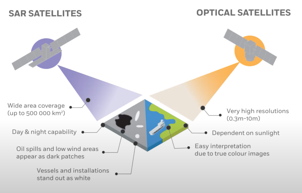
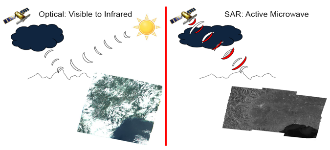
There are different types of satellite imagery. The types of imagery generated from a satellite depends on the kind of image-capturing method (remote sensing technology) it uses: active or passive sensors. Active sensors emit radiation towards the Earth’s surface and collect the reflected radiation. Lidar and Synthetic Aperture Radar (SAR) are both example of active sensors. SAR emits electromagnetic pulses whereas Lidar emits light pulses towards the Earth surface, both measuring the reflection. Passive (or Optical) sensors detect radiation naturally reflected from the Earth’s surface and are dependent on the day-night cycle.
For the purpose of site mapping, satellite imagery sourced using Optical satellites is most prevalent and useful (as these typically produce imagery with colour similar to how the human eye preceives color).
Satellites produce a range of different visual outputs. These visual outputs differ in their color combinations. Wavelengths detected by the satellites are translated into color bands then can combined to form an Index. This allows further analysis to be conducted. True-color images, as produced by Optical satellites and often used for mapping purposes, are a combination of the red, green and blue bands which results in an visual output similar to how we see color with our eyes. Other types of outputs include the Normalized Difference Vegetation Index (NVDI), which can be used to monitor changes in vegetation, or the False Color Infrared combination, which can be used in water detection during the heavy rain seasons or in the event of flooding.
3.2 Cloud cover
Passive satellites are not able to capture through clouds and therefore can be limited when observing certain areas with dense cloud coverage, posing a challenge to rapid response to hazards such as cyclones or floding.
3.3 Spatial resolution
The resolution of a satellite image is categorized as follows:
- High resolution: 30cm-5m/pixel
- Medium resolution: 10-30m/pixel
- Low resolution: over 60m/pixel
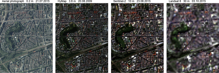
A 10m resolution means that each pixel represents a 10m x 10m area on the ground.The smaller the spatial resolution, the higher the level of detail.
Depending on the user’s needs, different image resolutions can be used:
High resolution images are used in scale analysis or monitoring since a smaller area is often covered. The level of detail at such spatial resolution allows for small and individual objects to be identified. High resolution images are ideal for humanitarian aid applications, detailed mapping, urban planning, as well as infrastructure, forestry and agriculture monitoring. However, high-resolution imagery is expensive and as a result, less of it is openly accessible. For the purposes of creating site maps, high resolution imagery is preferable.
Low to Medium resolution images are useful for understanding the bigger picture, whether that is looking at historical trends or deriving insights from spectral analysis. For example, ESA’s Sentinel and NASA/USGS Landsat data provide historical data at this resolution.
3.4 Imagery sources
Some free data sources for low to medium resolution imagery include USGS/NASA’s Landsat and ESA’s Sentinel series.
High-resolution imagery can be sourced from UNOSAT. Some satellite image providers also provide imagery for certain select disasters. An example of this is Maxar’s Open Data Program. OpenAerialMap can also be a useful source, where open licenced aerial imagery is made available for download.
For IOM staff, subject to availability, high-resolution Satellite imagery can be requested from IOM DTM GIS unit dtmgis@iom.int


